Lay of the Land
Sherman County lays claim to three wild and scenic rivers acclaimed for their windsurfing, kite surfing, fishing, sailing, boating, and scenic views.
Here you'll find the great Columbia River, which runs all the way from Canada before heading by Sherman County toward the sea. You'll find the Deschutes River, know for its whitewater rafting excursions. And you'll find the John Day River, site of the Oregon Trail Cut-Off and home to one of the most scenic, rugged landscapes in Oregon.
Explore each river's amenities below.
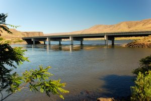
Columbia River
The Columbia River Basin is North America's fourth largest natural basin, draining about 250,000 square miles and extending throughout the Pacific Northwest and into Canada. There are more than 250 reservoirs and around 150 hydroelectric projects in the basin, including 18 dams on the Columbia River and the Snake River, its main tributary.
Fishing on the Columbia, Deschutes, and John Day rivers is popular and seasonal. Sportsmen come from near and afar to hunt deer, pheasant, quail, chukar, ducks and geese in the fall and winter. Windsurfing is especially challenging in the Columbia River’s unique wind and water conditions near Biggs and Rufus on I-84. The John Day Dam is near Rufus on the Columbia River, with Giles French Park just downstream from the dam.
River Destinations:
Lewis and Clark and the Corps of Discovery - The Columbia River
Starting in 1804, Meriwether Lewis and William Clark led the famous Corps of Discovery expedition from St. Louis to the Pacific Ocean and back, a journey that lasted two years. Since their instructions came from Thomas Jefferson in 1803, the Lewis and Clark bicentennial runs from 2003 through 2006.
- About the Lewis & Clark Trail
- Lithograph of Emigrants Crossing the Plains
- The Journals of Lewis & Clark
Maryhill
Maryhill Museum of Art, Maryhill State Park & Peach Beach, Maryhill, WA on the north bank of the Columbia River - wind surfing, boating, RV & tent camping across the Columbia River from Biggs and Rufus. www.maryhillmuseum.org
Giles French Park (say jiles)
Located on the downstream side of the John Day Dam on the banks of Lake Celilo, is popular for sturgeon, walleye and bass fishing, camping and boating. — U.S. Army Corps of Engineers

John Day Dam
U.S. Army Corps of Engineers
(541) 296-1181
John Day Dam, 216 miles upstream from the mouth of the Columbia River, is at the head of Lake Celilo. The Dam bridges the Columbia River near Rufus, Oregon, and can be reached via exit 109 off Interstate 84 East of The Dalles. Current Homeland Security does not allow visitor access to the any part of the facility.
The project consists of a navigation lock, spillway, powerhouse and fish passage facilities on both shores. Various recreational facilities are provided along the shores of Lake Umatilla and on the John Day River. Lake Umatilla, impounded by the dam, extends upstream about 76 miles to the foot of McNary Dam.
Construction began in 1958 and was completed in 1971, at a total cost of $511 million. At the time of its completion, John Day Dam Powerhouse was the second largest in the world. Completion of the John Day Dam marked the final step in harnessing the lower waters of the Columbia River.
Lake Celilo
Lake Celilo is a 24-mile-long reservoir and home to Celilo Falls behind the The Dalles Dam. This reservoir offers fishing, boating, and other recreation opportunities.
Known as the "Columbia River impoundment of The Dalles Dam," Lake Celilo can be accessed at:
- The mouth of the Deschutes River at Heritage Landing,
- Biggs Junction near the grain storage bins, and
- Giles French Park at Rufus.
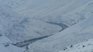
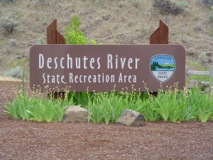
Deschutes River
 Deschutes River State Park (say deh-shoots) is an oasis on the east bank of the Deschutes Rivers. It's the confluence with the Columbia River on Highway 30 from I-84 exits at Celilo (seh-li-lo) and Biggs.
Amenities include Deschutes River State Park, an interpretive kiosk, an upriver abandoned rail bed trail for hikers and cyclists (and horses in season), camp sites, wildlife, views, restrooms, and picnic sites.
Did you know that:
- The Deschutes appears as Clark's River on the Lewis & Clark map
- Towarnahiooks is a Chinook term used for the river
- The French Canadian fur traders called it Riviere des Chutes, French for "river of the falls."
"October 22d [1805]. We left our camp ... and after going on for some six miles came to the head of an island [Miller Island] and a very bad [Hellgate] rapid ... Just above this and on the right are six huts of Indians ... two miles below are five more huts; the inhabitants of which are engaged in drying fish ... and some are in their canoes killing fish with gigs ... The island continues for four miles, and at the middle of it is a large river, which appears to come from the southeast, and empties on the left. We landed just above its mouth in order to examine it ... the natives had been digging large quantities of roots ... This river, which is called by the Indians Towahnihiooks, is 200 yards wide at its mouth, has a very rapid current ... about one-fourth as much water as the Columbia before the junction ... " — History of the Expedition under the command of Lewis and Clark, edited by Elliott Coues.
Deschutes River Campgrounds in Sherman County
Beavertail Campground is reached via Highway 216, ten miles north of Sherar's Bridge on the Deschutes River. Located on the bank of the Deschutes River, facilities include tent and trailer sites, picnic sites, water, firepits, handicap-accessible pit toilets, trails and a boat ramp. Visitors enjoy fishing, hunting, rafting,boating, views and geology. A Deschutes River boater pass is required for river use. -Bureau of Land Management.
Macks Canyon Campground is a 14-day campsite on the Deschutes River bank eight miles West of Grass Valley, reached via Highway 216 and north on the Lower Deschutes Access Road north of Sherar's Bridge. Facilities include picnic, tent and trailer sites, pit toilets, boat ramp,water, fire pits, andtrails. River users are required to obtain a boater pass. Visitors enjoy the site for its fishing, hunting, views, geology, rafting, hiking, and boating. Bicyclists and hikers enjoy the trail along the abandoned railroad grade. — Bureau of Land Management.
Jones Canyon Campground is 8.5 miles north of Maupin on the Lower Deschutes Access Road north of Sherar's Bridge. Facilities include picnic, tent and trailer sites, tables, fire pits, vault toilets, but NO water. Visitors enjoy fishing, rafting, boating, hunting, picnics, and the view. — Bureau of Land Management.
Twin Springs Campground is 15.5 miles north of Maupin on the Lower Deschutes River Access Road. Visitors enjoying fishing, rafting, hunting, geology, and hiking are furnished with picnic, tent, and trailer sites; tables; fire pits and vault toilets (but NO drinking water). Fees are required for camping and a boater pass is required for river use.
Rattlesnake Pass Campground, 22.5 miles north of Maupin, and north of Sherar's Bridge, on the Lower Deschutes River Access Road, is furnished with picnic, tent and trailer sites, tables, fire pits, toilets, boat ramp, and trails. Fees are charged for camping and a boater pass is required for river use. — Bureau of Land Management.
Buck Hollow is a day-use fishing and picnic site on the Deschutes River 9.5 miles north of Maupin on the Lower Deschutes River Access Road. Facilities include wheelchair accessible restrooms, vault toilets, and a raft-launch site. NO drinking water.
Deschutes State Park
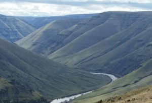
Deschutes State Park is an oasis on the east bank of the Deschutes at its confluence with the Columbia River. A national and state scenic waterway, the Deschutes drops about a quarter of a mile in its final 100 miles as it twists between canyon walls 700 feet to 2,200 feet high. Visitors enjoy day use, camping, fishing, boating, rafting, picnics, views, wildlife, hiking, bicycling, and horseback riding. Boater passes are required for river use. Cyclists enjoy access to the abandoned railroad grade along the east bank, also open to horseback riding at certain times of the year. The park has restrooms, but no showers, RV sites, primitive camp sites, and group RV/tent sites. — Oregon State Parks
For information call: (541) 739-2322 or 1 (800) 551-6949
For reservations call: 1 (800) 452-5687
Heritage Landing
Located on the West bank in Wasco County, Heritage Landing provides boat access to the Deschutes and Columbia rivers at the mouth of the Deschutes River.
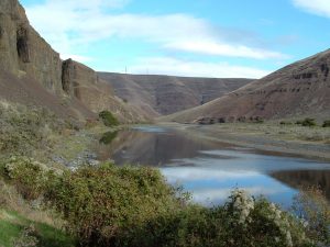
John Day River
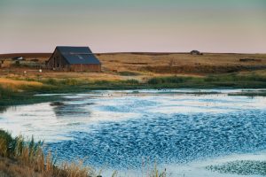
Cottonwood Canyon State Park
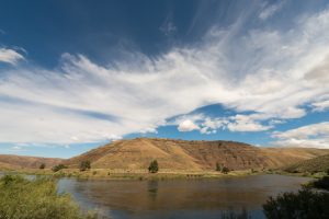
Located 15 miles southeast of Wasco, Cottonwood Canyon State Park offers visitors a unique opportunity to experience 8,000 acres of rugged terrain, scenic buttes, soaring cliffs, and the picturesque John Day River.
Upon entering the park, the historical Murtha family barn and an informational fence allow visitors to learn more about life in the last century through photos and short narratives taken from archival diaries, journals, and other written records. There are several artifacts to see, including a 90-pound wooden wagon wheel dating back to the early 1900s. The park offers many recreational opportunities, such as fishing, birding, exploring, rafting, kayaking, and canoeing.
Cottonwood Canyon State Park is the perfect get-away to relieve the stress of every-day life and give a sense of early-century Oregon farm life. Miles of trails accessible in the park make it easy for visitors to enjoy the wilderness. Walking beneath the primitive buttes and cliffs is an ideal way to reconnect with nature and to reestablish a relaxed state of mind. Come prepared to escape into solitude, get lost in spectacular views, and enjoy the exploration of one of Oregon's most scenic, rugged landscapes.
LePage Park at the John Day River’s confluence with the Columbia River is east of Rufus on I-84. Facilities include a boat ramp, dock, swimming area, picnic tables, and restrooms. — US Army Corps of Engineers
John Day River. Baptiste LePage.
"Monday, October 21st, 1805 ... On the left side of the [Columbia] river at this place are immense piles of rocks, which seem to have slipped from the cliffs under which they lie; they continue till, spreading still further into the river, at the distance of a mile from the island they occasion a very dangerous rapid [Squally Hook]; a little below ... on the right side are five huts. For many miles the river is now narrow ... the hills continue high ... a small river, which seems to rise in the open plains to the southeast and falls in on the left. It is 40 yards wide at its mouth, but discharges only a small quantity of water at present. We gave it the name of Lepage's river, from [Baptiste] Lepage, one of our company. Near this little river and ... below it, we had to encounter a new rapid... At the end of this rapid are four huts of Indians on the right, and two miles below five more huts on the same side. Here we landed and passed the night, after making 33 miles." — "History of the Expedition under the command of Lewis and Clark," edited by Elliott Coues