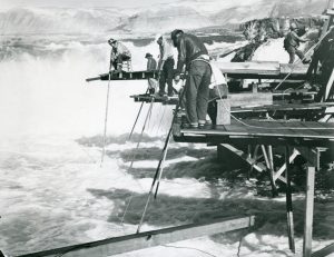
Native Americans net-fish at Celilo Falls, along the Columbia River, in this 1950s photo by Chet Coats, donated to the Sherman County Historical Society.
Native American Forerunners
For centuries preceding western settlement, Columbia Basin Tenino and Wyam Indians lived, fished, hunted, and traded along the three rivers that border Sherman County: the Columbia, Deschutes, and John Day.
For years after, Native Americans continued to travel through this "Land between the Rivers." They made their way through Sherman County to "the famed trading center at Celilo Falls to the west," according to records maintained by the Sherman County Historical Museum in Moro, Oregon.
Today, the Nez Perce Tribe, the Confederated Tribes of the Umatilla Indian Reservation, the Confederated Tribes of the Warm Springs Reservation of Oregon, and the Confederated Tribes and Bands of the Yakima Indian Nation continue to live in the Columbia Basin. You'll often find those tribes fishing along the Columbia River at spots including Horsetail Falls — just outside the County's northern border. The 1855 Columbia River Treaty gave all of these tribes the right to harvest anadromous fish. According to the most-recent Census data, 3% of the County population consists of native Indian, Polynesian, or other native peoples.
Settlers & Homesteaders
The county’s first permanent white settler was William Graham, who located at the mouth of the Deschutes River in 1858. Next came innkeepers and stage station, ferry and toll bridge operators. Stockmen followed with herds of horses, cattle, and sheep which ranged freely over the rolling bunchgrass hills. Jesse Eaton then settled at the head of Spanish Hollow. Homesteaders, eager for land, arrived in the 1880s by steamboat, stage, and wagon; shortly, farmers settled every quarter section. The area changed almost overnight from livestock country to a farming community as settlers built homes, plowed the grass, and fenced the rolling prairie in order to receive government patents.
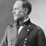
William Tecumseh Sherman as photographed by Mathew Brady.
Formation of the County
With the population growing and desiring independence from Wasco County, E. O. McCoy’s legislative bill creating a county to be called Fulton, after the pioneer Fulton family, passed in 1889. Established February 25, 1889, the new county was, however, named Sherman after General William Tecumseh Sherman of Civil War fame.
County development
The Oregon Trail brought the first European settlers to sky-high grasses on the rolling plains of Sherman County. From the 1860s, a series of stage, mail and freight routes crossed the county, connecting The Dalles with Boise, Umatilla, Walla Walla, and Canyon City.
The Dalles Military Road, established in 1868, cut from the northwest on the Deschutes diagonally toward Shaniko in Wasco County on the south, following a route used for years by pack train operators. Oregon Railway and Navigation Company trains roared down the Columbia from the John Day River to Celilo in 1881. This railway connected with the transcontinental line in 1883, bringing many settlers to this area.
The Columbia Southern Railroad, running from Biggs on the Columbia River to Wasco, was built in 1897 with much celebration as it ended long days of hauling wheat by wagon to the river. By 1901 the railroad reached Shaniko, a stretch of 70 miles. The county’s population swelled to 4,242 in 1910, during the James J. Hill and E.H. Harriman fight to build a railroad up the Deschutes River.
The Columbia Southern Railroad, running from Biggs on the Columbia River to Wasco, was built in 1897 with much celebration as it ended long days of hauling wheat by wagon to the river. By 1901 the railroad reached Shaniko, a monumental stretch of 70 miles.
Today, Interstate 84 parallels the Columbia River and old Highway 30, intersecting at Biggs with Highway 97 which traverses the full length of the county and links Sherman County to Washington State via the Sam Hill Memorial Bridge and points south. Highway 206, crossing the county diagonally, follows Fulton Canyon from the Columbia River through Wasco to Cottonwood Grade and the John Day River, destination Condon and beyond. Highway 216 connects Grass Valley to the juncture of Buck Hollow and the Deschutes River near Sherar’s Bridge and Sherar’s Falls.
The devastating flood of December 1964 ripped apart the rail line over which grain was shipped to Columbia River rail and barge facilities. Grain is now trucked from the field to farm storage bins and grain cooperative elevators where it is stored until sold and shipped. From there, enormous barges pushed by tugs ply the waters of the Columbia River to transport goods and fuel upriver and grain downriver for distribution.
Today, Sherman County is among the largest grain-producing counties in Oregon state. This grain is then shipped worldwide to form the building block of life as we know it.
Save
Save
Children play in this historic photo looking south from Wasco. Photo courtesy of the Sherman County Historical Society.